Internship Progress Week 5 (July 30 ~ August 05)
Internship Progress Week 5 (July 30 ~ August 05)
This week, my progress focused on developing a Nav2-based path planning and tracking solution for the Global Navigation exercise in RoboticsAcademy, utilizing standard global navigation algorithms already included in Nav2 instead of the custom GPP algorithm.
Here is the progress detailing how we implemented Nav2 and the current blockages encountered:
1. Implementing Nav2-based Solution for Global Navigation
Instead of implementing a custom GPP path-planning algorithm, we worked on utilizing standard ROS 2 Humble Navigation Stack (Nav2) packages:
- Static Map Configuration: Created
cityLargenBin.yamlto map the $500\text{m} \times 500\text{m}$ Gazebo city world coordinates to standard ROS 2 occupancy grid metrics (at1.25meters per pixel). This enables standard Nav2 map servers to feed the costmap. - Costmap and Nav2 Parameters: Configured
planner_server(using standardNavfnPlannerglobal path planner) andcontroller_server(usingRegulatedPurePursuitControllerlocal tracker) insidenav2_params.yaml. Static costmaps were tuned to run without LiDAR sensor dependencies. - Bridge Interface (
nav2_bridge.py): Developed a ROS 2 bridge node to translate JdeRobot’s WebGUI mouse click coordinates to standard/goal_posetopics and publish the resulting Nav2 planned paths back to the user GUI canvas. - Unified Launch Integration: Combined the Gazebo world server, robot spawner, static transforms, map server, Nav2 planners, and the GUI bridge into a single executable launch file
global_navigation_nav2.launch.pylinked natively to the database.
2. Current Blockages & Unresolved Issues
We are currently blocked by the following errors, preventing final verification of the Nav2 navigation loops:
- VNC Black Screen (UNRESOLVED): The VNC desktop screen (displays
:1and:2) remains completely black. The Gazebo GUI client fails to create its main rendering window, caused by Mesa software OpenGL emulation rendering bugs under Rosetta 2 translator on ARM64 macOS host. - Costmap TF Timeout Warnings: The costmap server throws continuous warnings:
Timed out waiting for transform from base_link to map to become available...because odometry is not published while the simulation physics is paused or the vehicle description joints are disconnected. - Verification Blocked: Because the simulation frontend and window manager rendering is black, we cannot visually verify if the Nav2 planner successfully drives the taxi vehicle to the selected target.
3. Visual Verification
Below is the static city occupancy grid map used for costmap planning:
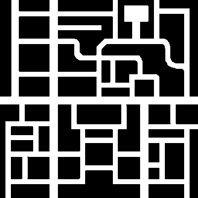 Figure: The binary occupancy grid map loaded into nav2_map_server.
This post is licensed under CC BY 4.0 by the author.